
View from Blackfriars Bridge

Blackfriars Bridge
Look here
Little Hulton Industrial Co-operative Society, Ltd.


Photographs taken 1961 on Mount Skip Estate, Little Hulton.


[1] Academy Architecture and Architectural Review, vol. 43 (1913).


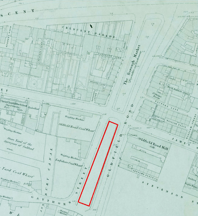
Oldfield Buildings were built in 1893 by the Yorkshire and Lancashire Railway Company. These working class tenements once housed sixty separate units. The structure was also known as Oldfield Road Buildings, Oldfield Road Dwellings, or, as they were simply called in my youth, "The Dwellings". They were located at the top end of Oldfield Road, toward Chapel Street, next to what was once the Borough Market (see 1850 map below), which sold vegetables and earthenware pottery and later became a recreational ground, though reduced in size. The site of Oldfield Buildings is marked on the maps below, and was built on a narrow strip of land between Graythorn Street and Oldfield Road.


Salford received its town charter from Ranulf de Blondeville, 6th Earl of Chester, then Lord of the Manor, in 1230. However, it did not receive borough status until 1844, the result of local government reforms embodied in the Municipal Corporations Act of 1835. This was followed by its elevation to county borough by the Local Government Act of 1888. It was granted city status in 1926. On the 1st of April, 1974, the City and Borough of Salford joined the metropolitan county of Greater Manchester.


The arms, designed by H. Ellis Tomlinson, combine elements of the five local authorities that formed the new city of Salford in 1974.
The shield retains were approved by letters patent of the Garter King of Arms and based upon the former Borough of Salford arms; the blue background with a gold 'chief', giving the heraldic colours of the Earls of Chester, from whom Salford received its first charter in 1230.
Also from Salford are the gold shuttle and five bees, representing the growth of five industrial communities round a centre of the textile industry, and the two black millrinds (the iron centres of millstones) as symbols of engineering.
The ship motif comes from Eccles and signifies the importance of waterways in the area. The crest, a red-half griffin holding a flag staff with a pennon, with three boars heads, is one of the former Eccles supporters. The boars heads were also seen in the Irlam arms, and the circle of steel around the griffin's neck was part of the Irlam crest, symbolising the town's great industry.
The supporters'-lions brandishing miners' picks are similar to those of Swinton and Pendlebury. Each lion is collared with a steel chain (a further symbol of engineering) holding a white pentagonal medallion. On one medallion is the black pheon, or broad arrow, which, with the red lion, appeared in the arms of Worsley, whilst on the other is the boar's head from the crest of Swinton and Pendlebury, shown in that former borough's livery colours of red and gold.
The motto, already described, is that formerly used by the Borough of Swinton and Pendlebury, Salus populi suprema lex ("The welfare of the people is the highest law").
In addition to its coat of arms, Salford City Council has its own "up-beat and highly visible" magenta-coloured logo.

Seal of the Hundred of Salford
In 1436, King Henry VI granted Sir Richard Molyneux of Sefton the office of Steward of the Wapentake of Salfordshire, to descend by hereditary right. This office was passed on through the Earls of Sefton until 1972.

Old University of Salford Coat of Arms


Arms seen at the head of a degree certificate and on its seal (1976)
New University of Salford Coat of Arms

A grant of Arms, Crest and Supporters was made to the University of Salford by Letters Patent of Garter, Clarenceux and Norroy and Ulster Kings of Arms dated 6 January 2017. On 10 February 2017 at Maxwell Hall, Salford, the Letters Patent were presented by Timothy Duke, Norroy and Ulster King of Arms, to the Chancellor of the University, Professor Jackie Kay, Makar or national poet for Scotland. An animated video on the new design can be seen here.
The Arms are blazoned:
Sable above a demi Sun issuant in base Argent charged with a demi Rose likewise issuant Gules barbed and seeded proper a Chain fesswise throughout enhanced and enarched and a Chief embattled and enarched Argent.
Crest: Upon a Helm with a Wreath Argent and Sable A Lion passant guardant Gules armed langued and resting the dexter hind paw on a Shuttle fesswise Or and supporting with the dexter forepaw a Fire Beacon Sable enflamed proper tied to the pole thereof by a knot at the mid point of its length and flying to the sinister a Riband party lengthwise Argent and Sable Mantled Gules lined Argent.
Supporters: On either side a Heraldic Antelope Sable attired langued and tufted Gules teeth Argent unguled and charged on the shoulder with a Bee volant Or and resting the interior hind foot on a Mooring Bollard Gules wound round with a Rope Or all upon a Compartment comprising a Quayside of grey stone setts issuant from Waves of Water proper.
College reference: Grants 180/72.
Source: College of Arms, April 2017 Newsletter (no. 50)
We stand at a pivotal moment in the long history of our university, a fork in the path that offers two ways forward. One is to follow the business model of higher education to its logical conclusion, in a competition for students, research funding and ratings that values constant change as an end in itself. The other is to rediscover the civic purpose of the university as a necessary component of the constitution of a democratic society, with the responsibility for educating its citizens and furnishing them with the wisdom and understanding that will enable them to fashion a world fit for future generations to live in.

The maps shown below are copies of a survey of Manchester and Salford done in the second half of the seventeenth century. To those familiar with the geography of the area, looking at map 1 (and like versions) is disorienting. Initially, I thought this was due to the process of engraving and printing: the print being a mirror image of the engraved plate. However, this is not the case.
According to the conventions of modern European cartography, based on the use of the compass and magnetic north, maps are normally oriented to the North, that is, North is at the top of the map. Map 1 is shown with a south-up orientation. It was simply printed upside down, and copyists followed this slavishly. By contrast, maps 4, 5 and 7 are printed in the conventional manner.
All of the maps shown below are copies of an original -- an editio princeps or archetype -- which is no longer extant. A careful study of their delineation shows that they differ in detail. For example, the 'F', representing Sergeant Street, seen on map 2, is absent from map 1. Map 1 has all the appearances of a 'rush-job'. Its Sacred Trinity Church, located at the apex of the 'Greengate Triangle' (see below) is reduced to a featureless box, while on map 2 it is iconic. Map 5 shows a similar Sacred Trinity icon, but it is the only map to have lost the symbol for Salford's market cross. There are also an obvious variety of legend styles. One way of looking at this is to create a stemma, which groups the maps into families.

The archetype is the lost original. Copyists created a version (a) defined by having no street names attached to the Greengate Triangle, and all have a south-up orientation (maps 1,2,8,10). This family has two subdivisions, a1 and a2. a1 (maps 1 and 2) refers to 'Sergeant Street' in the legend, and does not name the River Irwell. a2 (maps 8 and 10) do name the Irwell, but the legend, where present, does not mention 'Sergeant Street'. Version (b) names only Sergeant Street, and all examples spell the street name with a <g>. b1 (maps 6 and 9) are south-up oriented. b2 (maps 4 and 5) are north-up oriented. Within b2, b2a does not identify Acres Field (later to become St. Anne's Square). In version (c) all the streets of the Greengate Triangle are named, and both maps (3 and 7), use the variant spelling 'Serjeant' with a <j>. Unfortunately, this spelling can not be used as an indicator of chronology, since <g>, <i> and <j> were all used in the spelling of the word well before the middle of the 17th century. Maps 3 and 7 are distinct in showing a symbol or an icon for Manchester Cathedral and Sacred Trinity, while at the same time actually naming them. Within version (c), c1 (map 3) is south-up oriented, while c2 (map 7) is north-up oriented. This is only a rudimentary stemma, and any interested scholar would surely find further refinements.
Roeder's assessment of map 1 (c.1746) and map 6 (1822), led him to the following conclusion:
"There cannot be any doubt, however, that of the two plans. Berry's of 1746 and Yates's, the latter is the more reliable one, and, as I consider, the only genuine copy of the original, from which it was produced. I have placed before you, for inspection, a copy of Berry's and Yates's plan, and you will see at once that Berry's plan is very faulty — it seems to have been copied stealthily and in a hurry by somebody who had access to it. On examination you will find that part of Millgate, the whole block of Chetham College, the Session House, the block between Smithy Door and Deansgate, are put down wrong, and misleading; while Yates's plan shows them correctly drawn and strictly conforming in structure with Tinker's and Green's careful plans." [1]
You will notice on maps 4 and 6 that they were copied from a plan in the possession of William Yates, Esq. Any mention of William Yates in the context of maps, immediately brings to mind the cartographer responsible for creating the first modern map of Lancashire in 1786, but he is not the person referred to here. Our William Yates was an eccentric antiquarian collector, the son of David Yates, a Manchester upholstery trimmings manufacturer. William was responsible for purchasing two Medieval houses in 1822, which were about to be demolished in order the widen Market Street. He had the structures carefully dismantled, moved and rebuilt on Bury New Road, and the reconstructed building became known as 'Yates' Folly' or Knoll House. Also in 1822, John Palmer published his work, The History of the Siege of Manchester. It contained map 6, which was reproduced from a copy in William Yate's collection of antiquarian curiosities. Palmer's work was published by Manchester's premier antiquarian bookseller, William Ford. [2] It is known that William Yates was an avid customer of Ford's.[3], and it is more than likely that Yates purchased his map from Ford. Hence, Palmer knew of Yates' map through his publisher. Here the trail goes cold, because we have no idea where Ford might have acquired Yates' copy of the map. However, we have a time frame into which the archetype was created. It was produced after 1635, because that was the year Sacred Trinity was built, and it is included on the maps. Berry (maps 1 and 2) had seen a copy around 1750. Chetham's College, built in 1653, is named only on map 5, but its naming may have been a later addition and therefore of no chronological value. Roeder suggests that the original map may have been created as a response to the orders of the Court Leet of the Manor of Manchester on the 5th of October, 1669 to "survey the lands & tenements within the said town of Manchester that so every man may bear an equal portion in the said taxes." Whether or not the survey was completed is uncertain, but the problem persisted, and a similar order was issued on the 8th of October 1672. [4] The completed survey was presented to the court on the 8th of April 1673. A search for this document in the 1880s proved fruitless, but it is highly likely it is the lost archetype.
Maps: Right Click and Open in New Window to Enlarge


Map 1. [Inset] of A plan of the towns of Manchester & Salford in the county palatine of Lancaster, published by John Berry and Russel Casson. Manchester, c.1746, flat sheet. Engravings by B. Cole. sculp. [printed by] Palmer & Howe, Manchester.
Map 2. As above. Published by John Berry, grocer, at the New Tea Warehouse, Manchester, 1750. (coloured later). For full map see Manchester Archives
Map 3. [Inset] of A topographical plan of Manchester and Salford, with adjacent parts by Charles Laurent, published Dec. 9, 1793, Manchester. From A Description of the County from Thirty to Forty Miles Round Manchester by J. Aikin. (Engraved by John Cary). Reproduced in Views of Old Manchester (series 1) Manchester: Mancunium Velveteen, 1885, page 4.
Map 4. [Inset] of Manchester and its environs, engraved from an actual survey made in 1824 by William Swire, Leeds, for the History, Directory and Gazetteer of the County Palatine of Lancaster by Edward Baines, published by W. Wales & Co, Liverpool, 1825, 2 vols. (Engraved by Franks and Johnson of Leeds)
Map 5. Richard Hollingworth Mancuniensis; or, an history of the towne of Manchester, and what is most memorable concerning it. Manchester: W. Willis, 1839, frontis. (Engraved by Stephenson & Royston of Manchester)
Map 6. John Palmer The history of the Siege of Manchester by the king's forces under the command of Lord Strange, 1642. Manchester: Printed by John Leigh, 1822, frontis. Reproduced in J. Everett Panorama of Manchester and railway companion, Manchester, Everett, 1834, facing page 30.
Reproduced in Craig Homer (ed.) The Diary of Edmund Harrold, wigmaker of Manchester, 1712-15 Abingdon: Routledge, 2008, frontis.
Map 7. John Harland A volume of court leet records of the Manor of Manchester in the sixteenth century Manchester: Chetham Society, 1864, frontis.
Map 8. George Saintsbury Manchester: a history of the town London: Longmans, 1887. A version of this was reproduced in Robina McNeil and Richard Newman 'Post-Medieval Period Resource Assessment' 2006, Archaeology North West. 8. 145-164, page 151.
Map 9. William Arthur Shaw Manchester: old and new, vol. 1 London: Cassell, 1894, page 8 (map redrawn by H.E. Tidmarsh).
Map 10. Ernest Broxap 'The siege of Manchester in 1642' in Historical Essays, edited by T.F. Tout and James Tait. Manchester University Press, 1907, page 383. See also Broxap 1910 The Great Civil War in Lancashire map (cf. map 8).
The 'Greengate Triangle'


 |
| fig.1 click on images to enlarge source |
 |
| fig.2 Black's Road and Railway Guide to England and Wales. 14th ed. |
 | ||
| fig. 3 Looking up Trafford Road toward Salford. The Ordsall area is on the right
|
 |
| fig 5. Old Trafford Bridge with Trafford Road Swing Bridge beyond. This wonderful photograph was taken circa 1907-1917, from a rare angle source |
 |
| fig. 6. Close up of fig 5 showing the truss of Old Trafford Bridge, now spanning the railway |
 |
| fig 7. source |
 |
| fig. 8. source |
 |
| fig. 9 (1895) source |
 |
| fig. 10. source |
 |
| fig. 11 Trafford Road Swing Bridge on the left, Old Trafford Bridge on the right spanning the remnant of the River Irwell [2] Taken 1893 (Source: detail of T1133 The Frank Mullineux Collection of The Transport Archive) |
 |
| fig. 12. From left to right: Old Trafford Bridge, the electric and hydraulic engine station, the boiler room with chimney stack and the control tower [9], the pivot and Trafford Road Swing Bridge span. |
 |
| fig. 13. Both Old Trafford and Trafford Road Swing bridges are visible in the upper right hand quadrant of the illustration. Salford Docks 6, 7 and 8 are on the left. Trafford Wharf on the right. source: Scientific American v. 70, no. 10 (10 March 1894) |
 |
| fig. 14. source |
 |
| fig. 15. Trafford Road Bridge Complex with the Swing Bridge open. 'open' is used to mean 'the position of the bridge that allows ships to pass; 'closed' to allow traffic to cross the bridge. The vessel moored to the right of the bridge is probably the Firefly (see fig 33). |
 |
| fig.16 |

 |
| fig.17. source (detail) Trafford Railway Swing Bridge (above) and Trafford Road Swing Bridge (below) |
 |
| fig. 18. Oberkommando der Wehrmacht. Militärgeographische Angaben über England Berlin 1940 |
Main Span 129 ft. 6 in. Rear Span 82 ft. 3 in. Total Length over all 211 ft. 9 in. Height of Girders 30 ft. Width of Roadway 46 ft. ; Cart way 36 ft. Diameter of Roller Path (centres) 9 ft. 6 in. Number of Rollers 64. Weight when swinging 1,800 tons. Constructed by Messrs. John Butler & Co., of Stanningley. The bridge is worked by two hydraulic engines with independent gear, each being of sufficient power to open or close the bridge under ordinary conditions, but so arranged that they can be worked in conjunction if required. They are of Sir W. G. Armstrong, Mitchell & Co.'s ordinary type, with oscillating cylinders fitted with gun-metal plungers, gun-metal working and reversing valves, and oscillating joints. The bridge is turned by a cast steel rack fitted to the annular girder above the upper roller path. A central hydraulic ram 4 ft. 10 in. in diameter is provided, fitted with plunger and fixed to a cast iron bearing plate under the transverse girders of the bridge. During the operation of swinging one half of the weight of the bridge is taken by the central ram, reducing the load upon the rollers to 900 tons. The weight on the rollers is thus brought down to the initial load of 800 lbs. per lineal inch, the standard adopted for the whole of the rollers of the Swing Bridges throughout the Canal. Hydraulic gear for lifting and blocking the ends of the bridge, together with a locking bolt and disengaging gear are also provided. The movements of the bridge are arranged so as to be under the control of one valve man in the central cabin.(Transactions for 1896. Manchester Association of Engineers, Manchester 1897:161)
 |
| fig. 19 Three X-shaped trusses, positioned over the turning mechanism, add stability and strength to the structure. Since the turning mechanism is off-centre, the arc of the bowstring is asymmetrical, giving it a demi-ovoidal cross-section. Photo credit: J.Wallace Sutherland ( Manchester Locomotive Society) 
fig. 20
Inside a turning mechanism, showing spokes and roller ring.[3] This example is from the swing bridge at Stockton Heath, but the Trafford Road Swing Bridge mechanism would have been of much the same type. (Source: Engineering 26 Jan 1894)

fig. 21
The roller bearing ring of the Trafford Road Swing Bridge being assembled
(Source: T1111 The Frank Mullineux Collection of the Transport Archive)
"It works on a central hydraulic ram and sixty-four cast iron rollers" [5]
|
 |
fig. 22. Structural details and rivet work Photographer: unknown |
 |
| fig. 24. The seam between the bridge and the road, original brickwork |
 |
| fig. 25. Trafford Road Bridge (now fixed and being painted in 2015) and her new sister bridge |
 |
| fig. 26. 1893 source The 'passage for small craft' is actually a remnant of the River Irwell which has been incorporated into the Manchester Ship Canal. |
"a temporary swing bridge for railway traffic to and from the docks has been constructed, but will shortly be replaced by a permanent structure for railway communication with the Salford Docks." Engineering 26 Jan 1894:114
"The railway connections of both docks [Salford and Pomona] at present are obtained by a temporary railway swing bridge which crosses the canal immediately beyond Trafford-road swing bridges ... This bridge was originally erected for constructive purposes, and it will be superseded by a permanent steel swing bridge, carrying a single line, shortly to be erected close by." Engineering 26 Jan 1894:138
Messrs. Butler and Co., also contracted for the steelwork of the Trafford-road swing bridge, which is the heaviest in this country. The temporary swing bridge, close by—a remarkable structure, to which reference has already been made —was the work of this firm. The bridge, which is a steel structure, was made and erected in about two months from date of order. They are also the contractors for the permanent railway swing bridge which is to take the place of the temporary one. Engineering 26 Jan 1894:p.142
 |
| A very rare photo of the 'Temporary' Railway Swing Bridge'. We are looking up the River Irwell to Old Trafford Bridge. Trafford Road Swing Bridge can be seen to the left. [14] |
 |
| Practical Engineer 1 Jan 1904:18 |
 |
| Railway Swing Bridge (1) taken about 1896-98 Trafford Road Swing Bridge in distance Source |
 |
| fig. 27 Train on the Trafford Railway Swing Bridge (1) (taken circa 1910) Source: Manchester Archives The locomotive on the bridge has been identified as 'St. John' |
 |
| fig. 28 Trafford Railway swing bridge (no.2) in open position, with Trafford Road swing Bridge closed. 
fig. 29
Remnants of the old bridge: the centre pier (a) which held the turning gear;
resting piers or bases for closed position (b) an 'anchor' pier (c) and a 'starling shoe' (d); c and d are
both used when the bridge is open (see fig. 28) 
fig. 30
Trafford Railway Swing bridge being moved 1500 metres to its new location.
The work was undertaken by the Thomas Storey Group using 68 unifloat pontoons.
It took four hours to move the bridge using four Thomas Storey Motorflote propulsion unitsand an ocean-going tug acting as a brake. |
 |
| fig. 31. The old World War II veteran finds a new home |
Main Span 120 ft. 3 1/2 in. Rear Span 58 ft. Total Length of swinging portion 178 ft. Depth of Girder in centre 22 ft. 6 in. Weight when swinging 250 tons. Constructed by Messrs. John Butler & Co., of Stanningley. The swinging portion of the bridge is carried upon a central hydraulic press and ram, the latter being 2 ft. 10| 1/2 in. in diameter with 5 in. lift. The bridge is opened and closed by slewing chains working round a drum, which is fixed to the underside of the bridge and worked by two turning cylinders and rams fixed in opposite directions, one for opening and the other for closing the bridge. These rams are 9 1/4 in. in diameter and have a stroke of 5 ft. Two cast iron rollers are fixed under the head of the short arm. The bridge is controlled by one man in charge at the valve cabin. (Transactions for 1896. Manchester Association of Engineers, Manchester 1897:163-164)
 |
| Popular Mechanics, vol 7 (Jan 1905:128) |
 |
| fig. 32. 'Fire Float', Firefly, demonstration (Barton Bridge in distance) |


 |
| Marine Engineer Vol. XXVI. No. 308. 1 Nov 1904:299 |
 |
| Practical Engineer, vol 30, no. 921, 21 Oct 1904:472 |
 |
| Engineering: an illustrated weekly journal (London), vol 78, 7 Oct 1904:471 |
 |
| fig 33 Firefly on station next to Trafford Road Swing Bridge. Photo taken not earlier than 1905. There is a tram on the bridge.[13] |
 |
| fig. 34 Trafford Road Swing Bridge before electrified trams Photo taken by Thornton Ltd. of Altrincham before 1894 click on images to enlarge |

 |
| fig. 36 Looking toward Old Trafford. The building is a bank, most probably a branch of the Manchester & Liverpool District Banking Co |
 |
| fig. 37. Queen Victoria's Royal Visit in 1894 |
 |
| fig. 38 Fixture of lattice arch to the bridge |
 |
| fig. 39 Map 1902 showing the gap in tram services. Salford Trams stopped at the bridge Chester Road was the nearest tram line south of the canal source |
 |
| fig. 40 A tram can be seen in distance. Taken sometime before 1905 |
 |
| fig. 41. Trolley wires stop at the bridge portal |
 |
| fig. 42. wrought-iron lattice supports carry overhead trolley wires |
 |
| fig. 43 The post, located in the centre of the roadway (not on the bridge), carries electrical connectors. |
 |
| fig. 44. Taken 1932. The bridge handled two-way tram traffic |
 |
| fig. 45 Tramlines and tram with trolley attached to overhead wires click on images to enlarge |
 |
| fig. 46 Three posts secure the trolley wires (not on the bridge). The central post carries the connector. The bowstring truss of Old Trafford Bridge can be seen in the distance, on the left. A tram turns up Ordsall Lane. |
 |
| fig. 47. Scene showing connector posts and lattice arches at both bridge portals. (see also Manchester Libraries photo 9 below) |
 |
| fig. 48 Electricity connectors (bridge open) A conductor bar attached to the bridge slides into the brackets [a] as the bridge closes to make an electrical connection. |
 |
| fig. 49 With the bridge now closed, the conductor bar, attached to the lattice arch, slides into the suspended connectors. Once contact has been established, the trolley wires on the bridge are electrified.[4] |
 |
| fig. 50 Suspension frame: with bridge closed |
 |
| fig. 51 Bridge turning. Security gates closed. Conductor bar on the center pole disconnected. click on images to enlarge |
 |
| fig. 52. This is a notional reconstruction only, based on the photographic record. |
 |
| fig. 53. Taken 1934: bridge closing with conductor bar sliding into position |
 |
| fig. 54. Tram on the bridge |
 |
| fig. 55. Trams on the bridge. Safety lamp installed on connector post |
 |
| Engineering 26 Jan 1894:138 |
The machinery comprises two pumping engines, two boilers, tanks, feed apparatus, accumulator with pipes, valves and accessories, constructed by Sir W. G. Armstrong, Mitchell & Co. The two steam pumping engines are of the horizontal compound jet condensing type, each indicating 130 HP and discharging 180 gallons of water per minute at a pressure of 700 per square inch. The principal dimensions of the engines are 15 in. + 27 in. / 20 in. The high-pressure cylinder is fitted with double slide expansion valves, the normal rate of expansion with a steam pressure of 90 lbs. to the square inch is about nine volumes. The Boilers are Galloway's Patent Type, 6 ft. 6in. in diameter and 26 ft. long, with a working pressure of 100 lbs. per square inch. A Green's Fuel Economiser with 112 pipes is attached. The plunger of the accumulator is 20 in. in diameter and 23 ft. 6 in. stroke. (Transactions for 1896. Manchester Association of Engineers, Manchester 1897:162)
The engines at Mode Wheel and at Trafford Road work into the same hydraulic mains, and the pipes are so arranged that the Locks and Swing Bridges and the Docks may be worked from either place, either separately or together. Momentum valves are placed at intervals in the mains. In addition to the hydraulic mains, which are laid in subways round the whole of the quays and jetties of the Salford docks, a water main 4 in. in diameter has been laid round the Manchester and Salford docks, as well as on Trafford quay. (Ibid., 167) (see also Engineering 21 Aug 1903:266-267)


 |
| fig. 58 Control Tower (also known as the central cabin) has been allowed to fall into disrepair photographer: unknown |
 |
| fig. 59 Turning mechanism beneath Trafford Road Swing Bridge photo source: T1021 Frank Mullineux Collection of the Transport Archive |
The Steam Engines for this Installation are as follows : — (1) Two 100 B. HP Engines, by Mr. B. Goodfellow, of the vertical compound inverted cylinder type, 11 in. + 21 in. / 14 in. running 170 revolutions per minute, with a boiler pressure of 100 lbs. to the square inch. Both cylinders are steam jacketed, and each engine fitted with ejector condensers. Guaranteed consumption, 20 lbs. of steam per B. HP. A fly pulley 8 ft. 10 in. in diameter, grooved for eight ropes 1 in. in diameter, is placed between the cylinders. These engines drive two 60 Kilowatt Alternators and two Exciters (made by the Edison-Swan Company and supplied by Messrs. Baxendale & Co.), as well as the line shafting and the centrifugal pumps for condensing purposes. (2) Two 30 B HP Engines, by Messrs. Browett, Lindley & Co., of the vertical compound inverted cylinder type, 7 in. + 11 in. / 8 in., running 250 revolutions per minute, with a boiler pressure of 100 lbs. to the square inch, and a guaranteed consumption of 25 lbs. of steam per B. HP. Both engines are fitted with ejector condensers, and drive two 18-9 units continuous current dynamos, supplied by Messrs. Boyce & Co. Both sets of engines are arranged for working either condensing or non-condensing, and are capable of exercising their respective powers when non-condensing. One of Galloway's patent boilers, 26 ft. long and 8 ft. in diameter, working at a pressure of 100 lbs. to the square inch, was added to the existing boilers in connection with the hydraulic installation at Trafford Road, for the purpose of supplying the extra steam power required. The area lighted includes the whole of the Dock Quays and Sheds, and the Mode Wheel Locks; the lights are as follows: — 66 Continuous current Arc Lamps all 2,000 C. P. each, 28 Alternating Arc Lamps all 2,000 C. P. each, 360 Incandescent Lamps of 50 C. P. each, 100 Incandescent Lamps of 32 C. P. each, ,, 28 Incandescent Lamps of 16 C. P. each. Only incandescent lamps are used in the Dock Sheds. (Transactions for 1896. Manchester Association of Engineers, Manchester 1897:162-163) B HP (Break Horsepower); CP (Candle Power)
 |
| fig. 60. Valette: Trafford Road Swing Bridge |
 |
| fig. 61. Steamer passing through Trafford Road Swing Bridge by Henry Edward Tidmarsh (1855-1939) Old Trafford Bridge can be seen on the right. source |
 |
| fig. 62. A frame captured by Robert Wade from the film |
 |
| fig 63. Trafford Road Swing Bridge in all her glory, taken, one year after its completion, in December 1893 click on images to enlarge |
 |
| fig 64. The old Dock Office (centre) on the Stretford side of the canal. The tip of Trafford Road Swing Bridge can be seen on the right. This is a rare photograph. Its negative survives in the archive of the Science Museum Group. [15] |

 |
| Engineering 26 Jan 1894:118 |
FRANCIS HARRISON WALMSLEY, M.R.C.S. ENG., L.S.A., J.P. THE ranks of our profession in Manchester and Salford have again suffered grievous loss in the death of Alderman Walmsley of Higher Broughton, who has soon followed his neighbour, Dr. R. Crean. He was only taken ill on July 12th and died on the 16th. He was in his seventy-fifth year, but his neat, alert figure and air of activity told little of the weight of years. His father was a medical man, living in Dale-street, not far from the present infirmary, and there Walmsley was born. He decided to enter the medical profession, became a student at the Pine-street School of Medicine, now merged into the medical depart ment of the Owens College, and at the Manchester Royal Infirmary, and became qualified in 1849, soon obtaining an honorary surgeons to the Salford Royal Hospital, and after many years' service became one of the consulting staff. He took an active interest in public health, was one of the early members of the Manchester and Salford Sanitary Association, and was for a time one of its honorary secretaries. Though having the cares of a large and important practice he set an example of public-spirited activity in municipal work which, if it were more frequently followed by medical men, would be for the great good of the community. So far back as 1864 he was elected a member of the Salford town council, where he soon showed his interest in sanitary and educational matters and discussed them with an ability, which “speedily obtained for him recognition from his colleagues as an authority on sanitation and health.” At his death he had been an alderman of the borough for nearly 30 years. Soon after the passing of the Public Health Act, 1868, he submitted to the council a scheme, which was carried out, for the formation of a health department and the appointment of a medical officer of health. The question of river pollution has always been a serious one for Manchester and, Salford and Mr. Walmsley laboured hard for many years in the cause of purification, being an early member of the Mersey and Irwell Joint Committee and acting for some time as chairman of its chemical section. In 1877 he became chairman of the health committee of the Salford corporation and chairman also of the river Irwell conservancy committee. He was also one of the commissioners for dealing with the upper reaches of the Mersey. In 1876 he became Mayor of Salford and at the request of the council held the office for a second year. During these two years many important undertakings in connexion with Salford were completed. He was an ardent advocate and one of the original promoters of the Ship Canal. For many years he was an active member of the first School Board in Salford and later he was a representative of the magistrates of the borough, one of the governors of the Manchester Grammar School, and also a governor of the Owens College. He was an old member and ex-President of the Manchester Clinical Society, of the Medico-Ethical Society, and of the Certifying Surgeons' Association, and at the time of his death was President of the Medical Guild. From the year 1877 he was one of the magistrates of the borough and took his full share of magisterial work in connexion with asylums, &c. He was a generous supporter of many philanthropic institutions and, as one of the Manchester papers says, “his loss will be felt by the poor as keenly as by those in the very wide circle of his many admiring friends.” At the conclusion of the business of the Salford Police-court on July 17th, Mr. Makinson, the stipendiary magistrate, referred in sympathetic terms to Mr. Walmsley's death, to his kindness, and to his having been for many years “one of the most useful, honourable, and upright members of the Salford corporation.” One of his brother magistrates also bore testimony to his pains taking, judicious, and discriminating action as a magistrate and said that his “self-denying labours in the interest of the borough for a period of 40 years had rarely been equalled by any other citizen.” He was buried at St. John's Church, Higher Broughton, of which he was one of the trustees and an old member of the congregation; his funeral, which was largely attended, gave evidence of a widespread feeling of respect and sorrow.[9] Officially called the "Electrical and Hydraulic Installations of the Manchester Ship Canal at Old Trafford".
 |
| click on images to enlarge |


.jpg)